
By Judy Babb
Dallas is a virtual spider web of trails, connecting one part of the city to another and allowing people to see and enjoy places they would not see without the numerous well-trodden trails. The Dallas Trail Plan has more than 158 miles of trails, and has paths funded but not complete and paths planned for future development but not yet funded.
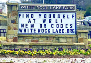
Photo by Marci Novak
White Rock Lake trails are 9.33 miles and growing. Some trails are linear — taking trekkers from one place to another. Others are loops that return those trail users to where they started. Within this nearly 10-mile trek across one of the most heavily used parks in the City of Dallas Park system are amenities that go beyond the expectations of a typical park.
Among those are the White Rock Lake Museum, the Bath House Cultural Center, the Dallas Arboretum, the Audubon Society bird watching area, wetlands, a dog park for large and small dogs, piers, boat ramps and a kayak concession. People can also rent a pavilion.
Now, thanks to a partnership between the Dallas Park and Recreation Department and community non-profit For the Love of the Lake, getting around the lake is easier. When park trekkers snap a certain QR code onto their phones, a map of the lake pops up. The project is tag lined “Find yourself at White Rock Lake.” The map is interactive, showing where visitors are as well as where points of interest and necessities are and how to get to them.
District 9 Park Board member Maria Hasbany is credited with seeing the need for the signs and approaching For the Love of the Lake president Z. Zsohar about the idea. The group was excited about the concept and was looking for a project to fund so Hasbany was able to go back to Parks and Rec to make it happen.
Zsohar was ecstatic about how quickly the concept became reality and with the fact that the signs help both visitors and the police.
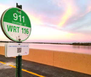
Photo courtesy of For the Love of the Lake
“Helping visitors who come here and get themselves lost is one of the key focuses of For the Love of the Lake,” Zsohar said. “We talked to policemen and they, from time to time, had to find peoples’ cars or tell them where they were or tell them how far it was to get from one point to another.”
He said the signs will be the thing that will help everyone. Hasbany and Zsohar were both pleased with the fact that the project took less than a year — a rarity in getting something through city hall.
“I had this brilliant idea, and, of course, Parks and Rec is so strapped in their budget,” Hasbany said. “For the Love of the Lake was looking for a project so they happily agreed to finance the graphic artist portion and to pay for the signs.”
Hasbany also saw a way of decreasing cost and adding visibility by having the “Find Yourself at White Rock Lake” signs placed on the same poles as the 911 signs, which were already around the lake. The signs are about a third of a mile apart. In addition to helping people know where they are and how to get to other places, the signs make it easy to report an emergency. The QR code and sign number can get help quickly.
Having the funding for the signs left the city with creating the map and coding for the interactive map. The department had a relatively new employee who had experience with coding who built the application.
The map includes links to the websites for the Bath House, Winfrey Point, the baseball fields and more.
Once the signs were installed, some Facebook accounts noted the addition of the new signs but didn’t know what they were for. Shortly after, yard signs were created and placed strategically to explain the QR code use. The marquee also promoted the QR codes. Signs at every entry point to the park called attention to them as well.
Hasbany said there is one other small park that has signs but nothing on the scale of White Rock Lake. She also noted the project is a pilot program for Dallas.
Dallas has a massive project going on called The Loop, which will ultimately connect all the trails citywide. Hasbany questioned what the plan was when all the trails were done.
She asked, “Do we have some way to build a big interactive map so when people are out there [at the lake] they know where they are, they know what trails are coming up, so they know how to get places.”
She discovered there was no plan. So Hasbany proposed the planners look at White Rock Lake.
“How about we do this,” Hasbany said. “We get this one done and if we like it and it’s useful and people are using it, we can use it as a pilot program.”
Expectations are high with the signs already being regularly used. That doesn’t mean the city could roll it out immediately.
“This is cobbled together with a little bit of donated money,” Hasbany said of the project. “I’m sure if we were to roll it out citywide — trail wide — there would have to be more work done. It would have to be scaled up.”
![]()
New QR codes help lake lovers find their way added by whiterocklakeweeklyadmin on
View all posts by whiterocklakeweeklyadmin →